


Non-profit organisation, the Augmented Reality for Enterprise Alliance (AREA) has released new research entitled 3D Mapping Solutions for Enterprise AR, which can review 3D mapping technologies, principles and define parameters for choosing a 3D scanner for specific use cases.
The use of 3D models or point clouds can reduce the cost, time and even developer training to view an object or environment with AR information like warnings, instructions or routes overlaid on the physical world.
Mark Sage, executive director of the AREA commented, “3D mapping technology has become pervasive throughout various industries to capture objects and environments in a digital format such as point clouds or 3D models. It allows for rapid visualisation, communication, and prototyping without the additional physical overhead.”
3D Scanning
AREA’s report described 3D Scanner as “a device which obtains the three-dimensional information necessary to digitalize totally or partially the surface of an object [or environment].”
The report also outlines some of the hurdles that can cause resistance to not only the current but also future usage of 3D mapping data in AR-assisted use cases. Some which are a lack of understanding of 3D mapping technology and techniques, limitations due to file formats, ideal scanner use cases, knowledge permitting a technician to accurately capture a suitable 3D dataset for AR, and guidelines for using AR and 3D mapping data together.
When using different approaches, 3D scanners can collect the shape and appearance of the object or environment using a laser that reflects off the object or environment that is being scanned.
The report identifies three categories of issues:
1) Issue of precision
The problem of precision was broken into three parts: Accuracy, geolocation and drifts. The accuracy of the scan will affect the implementation of the scan for AR authoring or usage. Geolocation will need to be improved as current hardware and software don’t have the required sensors to localise a user to a given location at a large scale.
An interviewee said that the, “Only way that we’re going to be able to establish someone’s pose, their location, and their tracking position is to give them accurate AR information.”
The report recognises drift as one of the primary issues when spatially anchoring an object within an environment. “They have trouble with drift… You put [something] on a table in a room, and you turn away, and you come back, and it’s here it’s a little bit off,” said the report. Adding that using anchor targets in AR experiences for frequent realignment is one way of mitigating drift.
2) Issue of usability
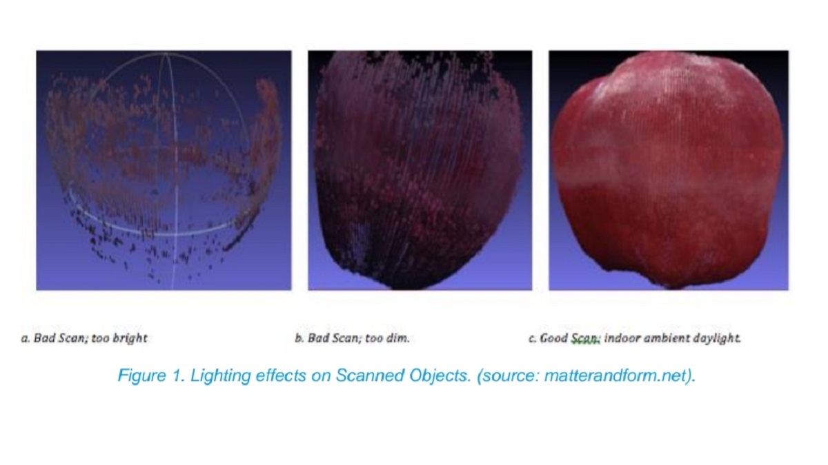
In this section, the report details that the scanners’ difficulty of use largely depends on environmental factors such as room lighting, air quality, etc. An example of this is the quality and uniformity of light, which can play a critical role in the quality of the resulting scan.
3) Issue of interoperability
AREA’s report states that there are various instances where data generated by 3D scanners or related software depends on specific elements that are only supported by the vendor’s hardware or software. In such a case, the data is either incompatible with alternate commercial software or requires a potentially pricey conversion step to become portable.
AR is rapidly evolving
And although it still has a relatively young presence in the enterprise sector, AR technology didn’t take long to evolve into a powerful tool with versatility and a community of experts.
“This research helps to inform enterprise on how 3D mapping technologies can be utilised to capture accurate, cost-effective digital representations of real-world environments, how this data can be leveraged in augmented reality applications, and why these concepts can be useful in industrial environments,” said Samuel Neblett, Senior AR/VR Software Developer and 3D Modeler, Boeing Research & Technology.
You can download an executive summary of the 3D Mapping Solutions for Enterprise AR research report from the AREA website.
Isa Muhammad is a writer and video game journalist covering many aspects of entertainment media including the film industry. He's steadily writing his way to the sharp end of journalism and enjoys staying informed. If he's not reading, playing video games or catching up on his favourite TV series, then he's probably writing about them.